updated 18 June 2026
This post describes the main erosion problems at 2CRU, DHA’s planning application PA 2026/0187 and FLP’s submission on the application. Application is at https://www.ntlis.nt.gov.au/planning-notices-online/notices#/index
Erosion problems on the western side of 2CRU
Defence removed vegetation many years ago from the western side of Lee Point – 2CRU (also known as Lot 4873 or Lyons North). This has led to large erosion gullies forming on defence land with sediment being carried into the mangroves – refer Offset erosion and sediment.
The erosion gullies have formed on land currently zoned Conservation (CN) and vested with Defence Housing Australia (DHA). DHA aim to transfer this land to the NT Government once erosion problems have been addressed. The NT Government is expected to include the land into the adjacent national park (known as Casuarina Coastal Reserve or CCR).
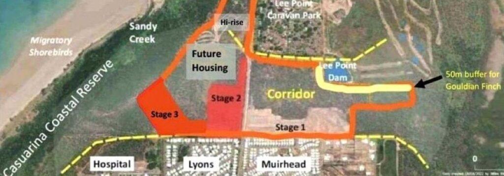
Fig 1. The main 2CRU erosion gullies are located southwest of Stage 3.

Fig 2. Four erosion gullies on the south-western side – excerpt from 2018 DHA Masterplan plus sedimentation note. The oval is at the approx location of the proposed detention basin.
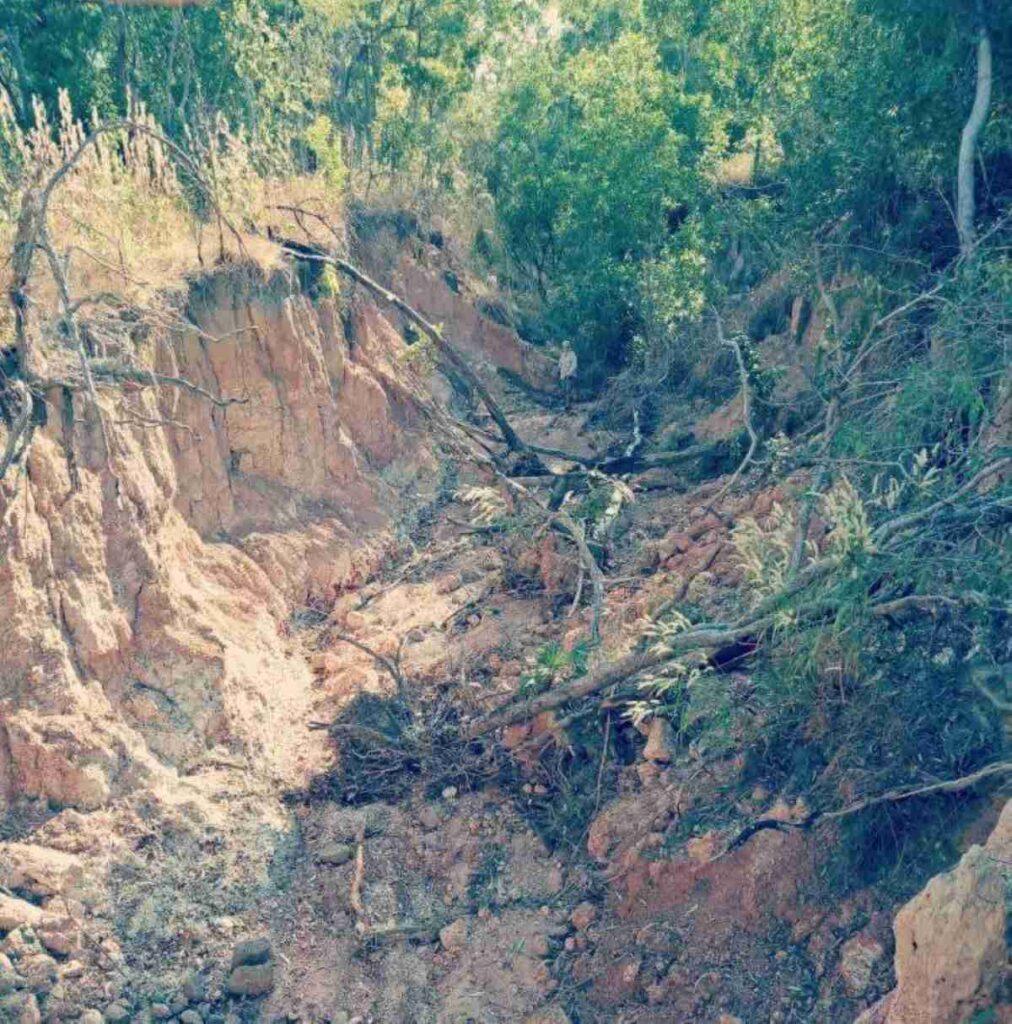
Fig 3. The largest erosion gully southwest of Stage 3.
DHA’s planning application PA 2026/0187 for fixing erosion problems at 2CRU
DHA have lodged a planning application PA 2026/0187, hereafter called Application. For details refer: https://www.ntlis.nt.gov.au/planning-notices-online/notices#/index
Erosion gully problems are to be addressed by building an upstream detention basin plus stabilising downstream eroded areas i.e. erosion gullies. The detention basin temporarily stores stormwater to reduce peak flows.
The erosion gully work involves filling, topsoiling and revegetating with appropriate native species. The fill and topsoil are to be sourced from the upstream detention basin.
The detention basin/erosion work is to be carried out as part of the 2CRU subdivision work during the dry season.
The detention basin is a separable part of the works and no details were provided in the Application.
Submission by Friends of Lee Point on PA 2026/0187
Prepared by Friends of Lee Point – 18 June 2026
Planning application PA 2026/0187 is not supported by Friends of Lee Point.
The additional following work is recommended:
- A preliminary design for the detention basin is undertaken to suit a conservation (CN) zone taking into account the adjacent Black-footed Tree-rat offset and national park
- The erosion and detention basin preliminary design (for a future CN zone) is presented in one document, and
- Free Prior and Informed Consent is sought from Larrakia traditional owners for all of the 2CRU erosion works.
Reasons
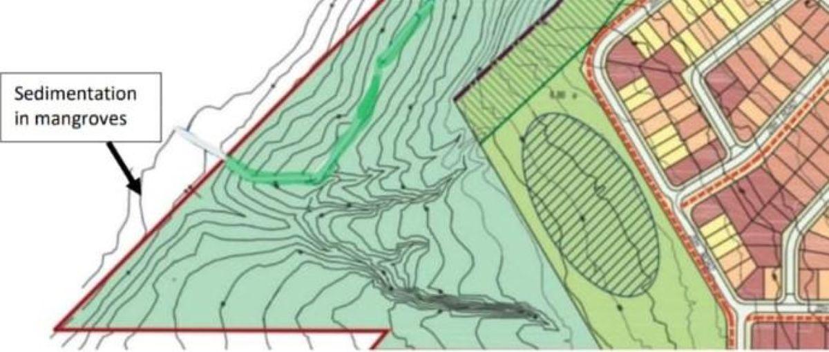
Fig 1. Four erosion gullies on the south-western side – excerpt from 2018 DHA Masterplan plus sedimentation note. The oval is at the approximate location of the proposed detention basin.
Lee Point Area Plan and zoning
The erosion works come under the 2015 Lee Point Area Plan. Community consultation for this Area Plan was inadequate (REF 1).
City of Darwin, Territory Labor and others have been calling for a moratorium on Lee Point works until a new Lee Point Area Plan is created by the NT Planning Commission. Many community groups (including Friends of Lee Point) believe that the Lee Point housing project should be relocated (REF 2) and more of the Lee Point peninsula zoned as Conservation (CN).
The proposed detention basin is adjacent to a national park and the endangered Black-footed Tree-rat (BFTR) offset area. The BFTR offset area (21.5 ha) is regarded as inadequate (by experts) and adjoining habitat needs to be conserved wherever possible. Hence, the basin should be in a CN zone not in a Future Development (FD) zone, as it is now.
Ideally the land between CCR and houses, refer Fig 1, (~4ha) would be rezoned from FD to CN while a new Area Plan (~500ha) is completed for the whole of Lee Point.
Rezoning the detention basin land from Future Development (FD) to Conservation (CN) will improve community acceptance of the erosion work and outcomes for the national park.
Detention basin work
There is inadequate detail on the detention basin work. The detention basin is given as the source of fill and topsoil for the erosion gully works and hence a critical part of the overall 2CRU erosion works. It should not be considered as a separable part.
The current detention basin appears to clear ~2 ha of intact habitat (a similar area to what is being restored). The value of retaining intact habitat in or near the detention basin area is that it requires little or no maintenance – a long-term saving for government.
Designing the detention basin in a CN zone means balancing habitat loss (clearing) against reducing peak flows. A preliminary design would help find this balance and better explain clearing works and the overall project to the community.
Additional fill and topsoil (if needed) for the erosion gullies could be sourced from the nearby 2CRU stockpiled soil mounds (less than 1 km away).
A preliminary design on the detention basin needs to be undertaken and included in the Application.
Cultural heritage
No mention is made in the Application whether Larrakia (traditional owners of Darwin) have been consulted on the proposed works. Previously, Larrakia objected to works at Lee Point for cultural reasons.
Free Prior and Informed Consent needs to be sought from Larrakia traditional owners for all of the works.