Lee Point needs a proper Area Plan
Please note this paper has been included here to help with internet search rankings, it is not recommended for printing. Please click here for a pdf print copy (16 pages) : Lee Point Cost Benefit
Preliminary Assessment
14 October 2020
EXECUTIVE SUMMARY
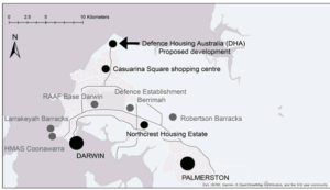
This preliminary assessment is in response to the proposed development of 800 houses (for 3000 people) by Defence Housing Australia (DHA) at Lee Point on lots 4873 and 9370. The assessment looks at the merits of locating future Australian Defence Force (ADF) personnel at Northcrest (near Berrimah Farm) and future rezoning of lots 4873 and 9370.
The scope of this assessment is limited in that it only considers Northcrest as an alternative site for housing future ADF personnel, and does not evaluate headworks cost, list relevant services for either Northcrest or Lee Point, e.g. education, health, recreation, retail, entertainment, which affect lifestyle, or consider different growth scenarios. Further work would be needed to better understand the costs and social benefits prior to engaging with stakeholders for both sites.
However, preliminary findings from the assessment indicate that future ADF personnel would be better and more affordably housed at Northcrest due to its central location and closeness to the major defence sites to reduce travel times. Similarly, there would also appear to be significant benefits in revisiting the best use of the Lee Point land having regard to the changes that have occurred since the use of this land was last reviewed in 2015. Current indications are that Darwin residents would welcome and support an urban planning study for the whole of Lee Point.
Rezoning of the Lee Point lots 4873 and 9370 to Conservation provides a potential opportunity to reduce development costs (for the taxpayer), grow ecotourism in Darwin, and significantly reduce the environmental impact that would come from the DHA’s proposed Lee Point housing development.
TABLE OF CONTENTS
- Background
- Sustainability
- Planning Issues
- Summary and Recommendations
APPENDICES
- Social Aspects – Travel Times
- Environmental Aspects
- Economic Aspects
- Planning Issues
- Bibliography
- BACKGROUND
Lee Point has played a role in a number of important historic events, such as the bombing of Darwin, the defence of Australia during World War Two and the Indonesian confrontation of the early 1960s. A radar station was located on lot 4873 (see map at Appendix B) until the early 2000s. The land is no longer used for military purposes.
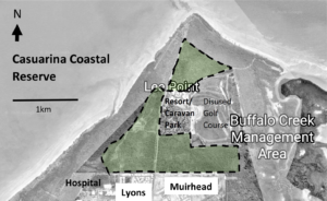
Defence Housing Australia (DHA) is proposing to build 800 houses (for 3000 people) at Lee Point, refer to Appendix E – (Ref 1). The houses are to be built on lot 4873, next to Casuarina Coastal Reserve (CCR), and lot 9370. Based on the Notice of Intent prepared for DHA in 2015, (Ref 2, Sec 1.4);
- Lot 4873, also called 2CRU (Lyons North) is owned by the Commonwealth, and
- Lot 9370, also called Muirhead North is owned by the NT Government.
Lee Point lots 4873 and 9370 were included in the NT Planning Scheme in 2015 (Ref 3). Two-year development permits were issued to DHA in 2018/19. The DHA development permit expires for lot 4873 on 30 November 2020, and lot 9370 on 27 February 2021.
DHA is wholly owned by the Australian Government. Its main function is providing housing and housing-related services to members of the Australian Defence Force (ADF) and their families (Ref 4).
Northcrest (168 ha), refer map below, is owned by Halikos Group, a Territory owned and operated business. Halikos Group has planned for 2000 houses plus a commercial development at Northcrest. The first land release (114 lots) commenced in March 2017 (Ref 5) and about 100 lots have been sold (5% of planned housing lots).
Darwin’s major defence sites (Ref 6), shown here in grey, provides the work place for most ADF personnel. The proposed DHA development is expected to result in about 800 residential lots, of which 30 per cent will be allocated for defence members (Ref 6).
2. SUSTAINABILITY
Sustainability is considered from three perspectives:
- Social;
- Environmental; and
- Economic
for the Lee Point Development (LP) and Northcrest Development with defence housing (NC).
Social
NC and LP are less than 10km away from a major shopping centre, school, medical centre, major sporting complexes, boat ramp, and nature reserve. However, NC offers a greater choice of services e.g. restaurants, shopping and entertainment due to its central location.NC’s central location would make it easier for ADF personnel to:
- cycle to work; cycling to the major defence sites from NC was assessed as easy to moderate, and from LP as moderate to hard, refer Appendix A;
- drive to work or use public transport (frequent bus services are available); and
- visit the Darwin CBD and Palmerston CBD.
LP provides walking access to a beach in Casuarina Coastal Reserve (CCR). However, for LP; “The NT EPA identified a potential conflict of siting an urban development near an existing wastewater treatment facility, with potential for offensive odours to impact on future residents’ lifestyle and amenity. Similarly, potential health impacts to residents from proximity to breeding habitat for biting insects is also of concern.” (Ref 7, Sect Summary).
Environmental
NC has minimal impact because the land was previously used for farming.
LP has a significant environmental impact. The inevitable introduction of more cats and dogs (predators) in the Lee Point region will threaten vulnerable or endangered wildlife species in the Lee Point area, such as migratory shorebirds, marine turtles, and Black Footed Tree Rat, refer Appendix B. Clearing of land will also reduce Darwin Cycad (classed as vulnerable) numbers and wildlife numbers generally.
Economic
Economic sustainability relies somewhat on eliminating spending where it is not needed.
ABC News reported in February 2019 that Darwin ADF numbers had fallen by more than 25% since 2010 (Ref 8), and in March 2020 the Australian Bureau of Statistics reported that the greater Darwin population had fallen by 0.8% in 2018/19 (Ref 9). The issue of housing oversupply needs to be fully considered, particularly in light of the associated high cost of public infrastructure that is required for housing developments, and current levels of high government debt.
NC is partly developed with some headworks in place. It is expected to have lower costs (per lot) than LP due to its central location. However, these costs are largely unknown.
Appendix C lists potential costs and a possible use for the LP land (if it is rezoned).
3. PLANNING ISSUES
Land Use Plans for any region are dynamic (not static), and should respond to changing circumstances: based on Darwin Regional Land Use Plan – Plan Purpose, 2015. (Ref 10)
Much has changed since the Lee Point Area Plan was incorporated into the NT Planning Scheme in 2015 (Ref 3). Darwin’s ADF personnel numbers have fallen significantly in the last ten years (Ref 6), and people are increasingly concerned about the environment, including the rate of greenhouse gas emissions and loss of biodiversity.
The risk of not rezoning Lee Point is that it could develop into an urban sprawl and residents find the northern suburbs less attractive to live in. The current zoning does not support the Australian Government’s Smart City Plan (Ref 11), refer to Appendix D.
The risk to the Australian Government of it not being able to use the Lee Point land (if it was rezoned), is non-existent because it has the power to override any Act of the Territory at any time. The loss of 800 house lots at Lee Point is not considered significant given the recent downturn in Darwin’s economy and potential to provide 2000 house lots at NC. In addition to this, the future city of Wedell (~10,000 lots south of Palmerston) could be advanced 1-2 years.
An extensive public consultation would be required for rezoning. However, current indications (refer Appendix D) are that an urban planning study would be welcomed and supported by Darwin residents.
4. SUMMARY AND RECOMMENDATIONS
Darwin needs long term jobs to sustain its population and improve its economy. The housing development at Northcrest (NC) appears to be more sustainable than at Lee Point lots 4873 and 9370 (LP) in all aspects; social, environmental and economic, due to its central location and closeness to the major defence sites to reduce travel times. Nor does LP appear to fit well with the Australian Government’s Smart City Plan. LP would be better rezoned to Conservation to promote ecotourism. However, these findings should be confirmed prior to engaging with stakeholders on the sites.
The following work is recommended to confirm the findings:
- Evaluate the cost of headworks (capital and recurrent) per lot at LP and NC, including indicative costs to meet NT EPA Assessment Report 88 requirements (Ref 7) at LP.
- Estimate the additional external costs (to be funded by the taxpayer) at LP to address; wildlife protection, traffic congestion, additional public transport.
- Assess the social benefits of living at LP and NC from known services in the area, and list these services.
- Comment on the environmental impact at LP versus NC, including greenhouse emissions from car travel.
- Discuss various future growth scenarios for Darwin in relation to housing supply, and the costs and benefits of advancing Weddell city over LP.
APPENDIX A
SOCIAL ASPECTS – TRAVEL TIMES
Shown below are indicative travel times to the main defence sites and CBD of Darwin and Palmerston.
Car Travel Time (assessment was made in June 2020 during off peak hour period)
|
Car Travel |
Darwin CBD Post Office |
Larrakeyah Barracks |
RAAF Base |
Defence Establishment Berrimah |
Robertson Barracks |
Palmerston CBD Post Office |
|
Lee Point |
20 min (17.1km) |
22 min (17.7km) |
15 min (13.1km) |
16 min (12.2km) |
19 min (16.9km) |
22 min (21 km) |
|
Northcrest |
13 min (12.6km) |
16 min (14.2km) |
9 min (8.5km) |
6 min (3.4km) |
12 min (9.6km) |
11 min (10km) |
|
Difference
|
7 min (4.5km) |
6 min (3.5km) |
6 min (4.6km) |
10 min (8.8km) |
7 min (7.3km) |
11 min (11km) |
- Car travel times will vary according to traffic, i.e. time of day and year. Google Maps (Directions) was used to estimate car travel times.
- Car travel from Lee Point to Darwin’s major defence sites ranges from; In time: 15-22 min and is 6-10 min longer than from Northcrest. In distance: 12.2 – 17.7km which is 3-9 km further in distance than from Northcrest.
FUTURE TRAFFIC CONGESTION
Traffic congestion is a condition on transport that is characterised by slower speeds, longer trip times, and increased vehicular queueing.
During the morning peak hour, vehicles heading south from Lee Point to the Vanderlin/Lee Point Road roundabout causes vehicles to queue on the eastern side of the roundabout. Traffic delays from queueing (see photo below) were generally less than two minutes.
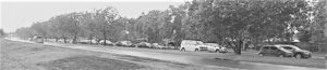
Vanderlin/Lee Point Road roundabout (looking east) – morning peak hour – Sept 2020
The proposed DHA development will increase the number of vehicles heading south from Lee Point. This in turn is expected to increase queueing/time delays, particularly for vehicles east of the roundabout, and queueing/time delays (traffic congestion) could increase substantially. However, a traffic study would be needed to confirm this.
Bicycle Travel Time (assessment was made in July 2020 during off peak hour period)
|
Bike Travel |
Darwin CBD Post Office |
Larrakeyah Barracks |
RAAF Base |
Defence Establishment Berrimah |
Robertson Barracks |
Palmerston CBD Post Office |
|
Lee Point |
54 min (17.9km) |
56 min (18.6km) |
41 min (13.9km) |
42 min (12.8km) |
50 min (17.1km) |
67 min (22.3 km) |
|
Northcrest |
41 min (12.6km) |
45 min (13.5km) |
26 min (8.5km) |
9 min (3.1km) |
29 min (9.6km) |
30 min (9.5km) |
|
Difference
|
13 min (5.3km) |
11 min (5.1km) |
15 min (5.4km) |
33 min (9.7km) |
21 min (7.5km) |
37 min (12.8km) |
Notes:
- Google Maps tends to select bike tracks which can increase distance compared to car travel.
- Bike travel from Lee Point to Darwin’s major defence sites ranges from;
In time: 41-56 min and is 11-33 min longer than Northcrest
In distance: 12.8 – 18.6km and is 5-10 km further in distance than from Northcrest.
- Cycle to Work website rates cycling difficulty as; 0-8kms as easy, 10-16kms as moderate, 18-24kms as hard.
Bus Travel Time (based on 2020 bus timetables and Google Map directions)
From LP (Muirhead): Frequency at peak hour is 30 min, Frequency off peak 1 hour.
Bus travel time from LP to Casuarina Bus Interchange (CBI) is 10 min
From CBI: Frequency peak at hour is 25 min, Frequency off peak 35 min.
Bus travel time to defence sites is 15-30min.
Expected travel time LP to defence sites: Peak hour is ~1 hour, off peak up to 2 hours.
From NC (Stuart Hwy): Frequency at peak hour is 20 mins, Frequency off peak 35 min.
Bus travel time from NC to defence sites is 10-30 min.
Expected travel time NC to defence sites: Peak hour is 10-20 min, off peak 10-30 min.
Notes:
- Robertson Barracks is not serviced by public buses, and all LP buses go to CBI.
- Bus travel time is from first bus stop to final bus stop and includes time to change buses.
Findings
ADF personnel are expected to spend significantly less time driving if they lived at Northcrest (NC) than at Lee Point (LP). Time saving each day is 12-20 min (6-10 min one way). LP car travel times are expected to increase (from proposed DHA housing development) in peak hour periods, with road users east of Vanderlin Drive/Lee Point roundabout being the most affected.
More ADF personnel are expected to cycle to work if they lived at NC than at LP. Cycling to the major defence sites from NC is considered to be easy to moderate, and from LP moderate to hard.
More people are expected to use public transport if they lived at NC than at LP. For ADF personnel, bus travel time from LP to the defence sites is expected to be about twice as long as that for NC because it involves changing a bus at Casuarina Bus Interchange.
APPENDIX B
ENVIRONMENTAL ASPECTS
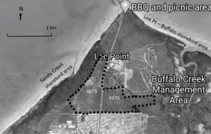
Dashed line shows the area to be cleared for housing and commercial purposes within Lots 4873 & 9370, it does not show actual lot boundaries. CCR is to the west and north of this area.
Protection of wildlife
The NT Government and City of Darwin have been running programs to protect wildlife from cats and dogs. With the proposed housing of 3000 people (and hundreds of cats and dogs), protection of wildlife at Lee Point will become much more difficult.
CAT PROBLEMS
Domestic cats are recognised as a major problem to native wildlife in Australia. The Australian Government (Standing Committee on the Environment and Energy) is currently undertaking an: “Inquiry into the problem of feral and domestic cats in Australia” (Ref 12). Submissions closed 30 July 2020, with two submissions received from Darwin, NT.
In Dec 2019, the ABC reported that “Feral cats plague Darwin as council ramps up cat management program” (Ref 13), and that “the Casuarina Coastal Reserve Landcare Group have been worried about cats from two new Defence suburbs planned at Lee Point.”
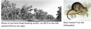
One species at threat from cats at Lee Point is the Black Footed Tree Rat. It is classed as vulnerable in the NT and endangered nationally. Its numbers have fallen sharply in the NT since 2002 (Ref 14). Possible reasons for the decline include loss of suitable habitat and predation by cats. In 2017, it was photographed in Lot 9370 as part of the EIS process. The habitat in the photo is considered to be good habitat for this species (Ref 15, Appendix M).
Options to deal with feral and domestic cats such as; cat containment, trapping of cats and cat proof fencing all involve capital and maintenance costs for the taxpayer.
DOG PROBLEMS
Migratory shorebirds need to fly many thousands of kms from the southern hemisphere to north-eastern Asia to breed, and not all of them make it. Being in peak condition and having adequate fat reserves (fuel) before they leave is crucial; dog disturbances burn up valuable fat reserves.
Thousands of migratory shorebirds (over 20 species) visit Lee Point each year. One of the most easily disturbed is the world’s largest shorebird, the critically endangered Far Eastern Curlew. It commonly relies on the Yellow Sea as a migratory stopover. In 2019, China with great support from Australia secured World Heritage status for small areas of the Yellow Sea. This was done to help protect feeding areas for migratory birds such as the Far Eastern Curlew.
In July 2019, the 10th Annual Australasian Ornithological Conference was held in Darwin attracting more than 300 researchers and scientists. Part of the event included a visit to a Lee Point shorebird feeding site to count shorebirds. ABC News reported (Ref 16) that, “all the (7) researchers were saddened and disappointed” by the visit because the shorebird feeding site had been disrupted by dogs.
Dog disturbances are an ongoing problem at the Lee Point shorebird feeding sites, despite the best efforts from NT Parks and Wildlife (which need more resources). Over the last two years, the authors have seen many (uncontrolled) dog problems at Lee Point beaches and have reported some of them to NT Parks and Wildlife.
More resources for dog management will be required if LP proceeds. An added cost, if Darwin is to retain its reputation as an internationally significant shorebird site.
APPENDIX C
ECONOMIC ASPECTS
Developers typically carry the short-term costs directly associated with the development, and the taxpayer the remainder.
Development costs
The development costs at LP and NC need to be better understood as well as the ongoing costs for the developments. Costs are discussed below:
UTILITY COSTS (water, sewerage, electricity services).
At LP (for a population 3000 people) headwork utility costs could exceed $15M. It’s likely that LP will require a new water storage facility, sewage pump stations, and HV feeder. There are possible upgrades to sewage treatment ponds and the electrical substation. At NC (for a population of 7000) more of the headworks would have been set up as part of the first stage. In addition to this NC should have lower headworks cost per lot than LP due to its central location.
TRANSPORT COSTS (road, car and public transport services)
There is significantly more car travel from LP compared to NC. Car travel costs have yet to be evaluated, nor has the greenhouse gas emissions (due to increased car travel).
In 2012, the City of Darwin estimated developer contribution cost for the roadworks from Muirhead to Lee Point would cost $4.1M (Ref 17). The Lee Point/Vanderlin Drive roundabout is at capacity in the peak hour (based on queueing along Vanderlin Drive), and upgrades could be required for LP, costs for this is unknown.
The cost to increase and operate an expanded bus service at LP has not been scoped or costed. NC already has bus services.
ENVIRONMENTAL COSTS
The NT EPA (Ref 7, Recommendations) places stringent conditions on LP to reduce the significant environmental impact. It includes implementing a shorebird monitoring program, protecting marine turtles, stormwater discharge to tidal areas, cautionary notes to property buyers about biting insects, plus other requirements. This will increase costs at LP.
The future management of cat and dog problems at LP (refer previous section, Protection of Wildlife) still needs to be scoped and costed.
SUMMARY OF TAXPAYER COSTS
The higher capital and maintenance costs for the taxpayer at LP (per lot) compared to NC is a result of:
- LP being on the fringe of the Darwin network resulting in longer lengths of water pipes, electricity lines, and roads to be built (or upgraded) and maintained,
- A larger area needing to be serviced by public transport, and
- LP being in an environmentally sensitive area.
Ecotourism
Ecotourism is considered to be the fastest growing sector of the tourism industry. In August 2019, Ecotourism Australia reported based on its 500 high standard tour operator members in the past two years, an overall 54% increase in jobs and a 14% increase in annual revenue (Ref 18). The ecotourism statistics given for the NT was, a 19% increase in jobs and a slight decrease in annual revenue.
Having tourists stay in Darwin longer to visit places like Lee Point is good for the Darwin economy. Casuarina Coastal Reserve (CCR) has over 1M visits a year (Ref 19) mainly from local residents, and increasing. About 50% of Lee Point land can be accessed by the public.
PUBLIC ACCESS TO LAND AT LEE POINT
The Lee Point land area is described (in this paper) as land north of; Lyons and Muirhead, mangrove boardwalk and Muirhead drain. It is bounded by Buffalo Creek and the beach at high tide. This gives (using Google Maps) a total land area of 5.25 sq km at Lee Point. Some areas are affected by tide, plus the area to the south east consists of poorly drained silt/clay soils (Ref 20, Fig 3.2) which is inundated in the wet season making it unsuitable for walking/biking trails. This leaves about 4.5 sq km at Lee Point suitable for general public use.
Current suitable land available (in sq km) for free public use at Lee Point is:
4.5 total land area suitable for general public use
-0.3 Resort and Caravan Park (private property).
-0.7 Disused golf course
-1.1 Disused defence land (LP land)
-0.3 Fenced area north of the resort
2.1 sq km total area available for free public use
- The general public has free access to approx. 50% of suitable land at Lee Point.
- The LP land comprises approx. 24% of the total suitable land area at Lee Point.
- Public access to suitable land at Lee Point could be increased from approx. 50% to 90% if the LP land, disused golf course land and fenced area north of the resort land was included in a conservation reserve.
All land at Lee Point is believed to be owned by the government except the Resort and Caravan Park.
ECOTOURISM POTENTIAL
A potential use of the LP land could involve nature walks, birdwatching, aspects of aboriginal culture, bike trails, and defence history. While LP has some attractive woodland, Darwin Cycads, and a small rainforest, parts of it would need to be cleaned up (rubbish removed).
In September 2020, a nature walk held by the NT Field Naturalists at the Lee Point dam area (south of Caravan Park) attracted over 50 people. The walk identified 40 species of birds in less than 2 hours; which is comparable to CCR. CCR is advertised as a birdwatching location on the Northern Territory Government’s tourism website.
Mountain bikers regularly use part of the LP area. Darwin Off Road Cyclists (DORC) are promoting mountain bike riding at Lee Point.
There is currently a concept for a coastal trail (walking/cycling) from the CBD to Lee Point. The coastal trail, some of it already constructed, would pass by areas of interest such as the East Point Military museum. LP could provide another “area of interest” on the coastal trail. Accommodation is available at the nearby Lee Point Village Resort.
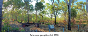
For defence history, it would mean obtaining and displaying additional defence relics/signage as many of the relics have been removed. Based on the NT EPA (Ref 7, Sect 5.1.2), lot 4873 contains the remains of a missile launching facility and explosives store, and remnants of anti-aircraft battery sites. Lot 9370 has the remains of a defensive gun pit.
APPENDIX D
PLANNING ISSUES
NT Government
In 2015, the NT Government released its Darwin Regional Land Use Plan (Ref 10) which included seven “Key residential objectives”, the three most relevant to this paper are:
Ensure sustainable development by encouraging:
- the efficient use of land, water, energy and other resources
- accessible and efficient public transport to reduce transport demands
- cost effective provision and efficient utilisation of infrastructure and services
Australian Government
In 2016, the Australian Government launched its Smart City Plan (City Deals are part of this Plan). Under this Plan, housing is encouraged to be located near jobs and transport (Ref 11, Housing).
In 2017, the NT Government and Australian government signed a Memorandum of Understanding to work cooperatively together on City Deals. The first Darwin City Deal ($200M) was signed in 2018 and an implementation plan was produced on November 2019.
In essence, the (3) NT key residential objectives above align with the Australian Government’s Smart City Plan. Issues such as the efficient use of land, accessible and efficient public transport, cost effective provision and efficient utilisation of infrastructure and services are common to both.
Planning for Lee Point
Rezoning the Lee Point land from Future Development to Conservation encourages housing development at NC, an action which promotes the efficient use of land, infrastructure and services, and in turn supports the Smart Cities Plan. It also avoids possible future traffic congestion at the Lee Point/Vanderlin Drive roundabout.
Proceeding with housing development at Lee Point (such as the proposed DHA development) results in; increased travel time, car dependency, habitat loss, plus risks traffic congestion and introduction of invasive species ie. cats; in short, an urban sprawl. Aspects of this was discussed at a public meeting held at the Lyons Community Centre on the 25 July 2020. The majority of the (35) people present wanted a moratorium on future housing at Lee Point.
Furthermore, it appears that most Darwin residents are not aware of the proposed DHA development. The authors spoke to 115 people during a flyer drop for the Lyons public meeting in Tiwi, Lyons and Muirhead in July 2020; only 21 people had heard of the proposed DHA development (less than 1 in 5) and only one person appeared to support it. Many people couldn’t understand why housing was being proposed at Lee Point.
It is apparent from this and subsequent discussions that an urban planning study for the whole of Lee Point would be welcomed and supported by the public.
APPENDIX E
BIBLIOGRAPHY
Ref Title
- Defence Housing Australia website: https://www.dha.gov.au/development/residential/lee-point
- EcOz Environmental Consultants: Lee Point Master-planned Urban Development: Notice of Intent, prepared for Defence Housing Australia, June 2015 https://ntepa.nt.gov.au/__data/assets/pdf_file/0007/287602/noi_lee_point.pdf
- NT Government: Planning Scheme Amendment No 369, Aug 2015: https://nt.gov.au/__data/assets/pdf_file/0009/205884/amendment-369.pdf
- Australian Government Department of Finance: Defence Housing Australia: https://www.finance.gov.au/business/government-business-enterprises/defence-housing-australia-dha
- Halikos website: https://northcrest.com.au/faqs/
- NT Department of Treasury and Finance: NT Defence: https://nteconomy.nt.gov.au/industry-analysis/defence
- NT EPA: Assessment Report 88, Oct 2018 – refer to NT EPA website: https://ntepa.nt.gov.au/__data/assets/pdf_file/0009/593703/assessment_report_lee_point_urban_dev.PDF
- ABC News, Feb 2019: https://www.abc.net.au/news/2019-02-17/defence-numbers-down-annually-since-2010-darwin/10794850
- Australian Bureau of Statistics, March 2020: https://www.abs.gov.au/statistics/people/population/regional-population/2018-19
- NT Government: Darwin Regional Land Use Plan, 2015 https://nt.gov.au/__data/assets/pdf_file/0019/240247/darwin-regional-land-use-plan-2015.pdf
- Australian Government: Smart Cities Plan, 2016 https://www.infrastructure.gov.au/cities/smart-cities/plan/index.aspx
- Australian Government: Standing Committee on the Environment and Energy: Inquiry into the problem of feral and domestic cats in Australia, 2020 https://www.aph.gov.au/Parliamentary_Business/Committees/House/Environment_and_Energy/Feralanddomesticcats
- ABC News, December 2019: https://www.abc.net.au/news/2019-12-01/feral-cats-targeted-by-darwin-council-rangers-with-cat-traps/11746160#:~:text=In%20the%202018%2F19%20financial,rehomed%2C%20and%20362%20were%20euthanised.
- NT Government: Black Footed Tree Rat, 2012: https://nt.gov.au/__data/assets/pdf_file/0018/205515/black-footet-tree-rat.pdf
- ECoZ Environmental Consultants: Lee Point Master-planned Urban Development EIS, Appendix M – Black-footed Tree-rat Survey Report, June 2017: https://ntepa.nt.gov.au/__data/assets/pdf_file/0011/593687/supp_draft_eis_lee_point_urban_dev_appendixM_blackfooted_tree_rat_report.PDF
- ABC News, July 2019 https://www.abc.net.au/news/2019-07-11/dog-owners-ignore-protected-birdlife-signs-at-darwin-beach/11299254
- City of Darwin: Developer Contribution Plan for Roadwork, Lee Point Road – Vanderlin Drive to Lee Point Reserve, November 2012: https://www.darwin.nt.gov.au/sites/default/files/publications/Appendixs/lee_point_road_roadwork_developer_contribution_plan.pdf
- Ecotourism Australia, Media Release, August 2019: https://www.ecotourism.org.au/news/media-release-ecotourism-in-australia-delivers-over-14000-direct-jobs-and-1-6-billion-annual-revenue/
- NT Government: Parks and Wildlife – Park Visitor Data, 2019: https://dtsc.nt.gov.au/parks-and-wildlife-commission/parks-and-wildlife-statistics-and-research/park-visitor-data
- EcOz Environmental Consultants: Muirhead North Stage 1 Preliminary Site Investigation, April 2015, https://ntepa.nt.gov.au/__data/assets/pdf_file/0008/593693/supp_draft_eis_lee_point_urban_dev_appendixS_muirhead_north_stage1_prelim_site_investigation.PDF
Acknowledgements
This paper would not have been written and published without the support and encouragement from the following Darwin residents:
David Percival, Amanda Lilleyman, Margaret Clinch, and Nick Kirlew.