This is a preliminary report on the erosion problems occurring in the Defence Housing Australia (DHA) offset area, located in the southwest corner of 2CRU at Lee Point.
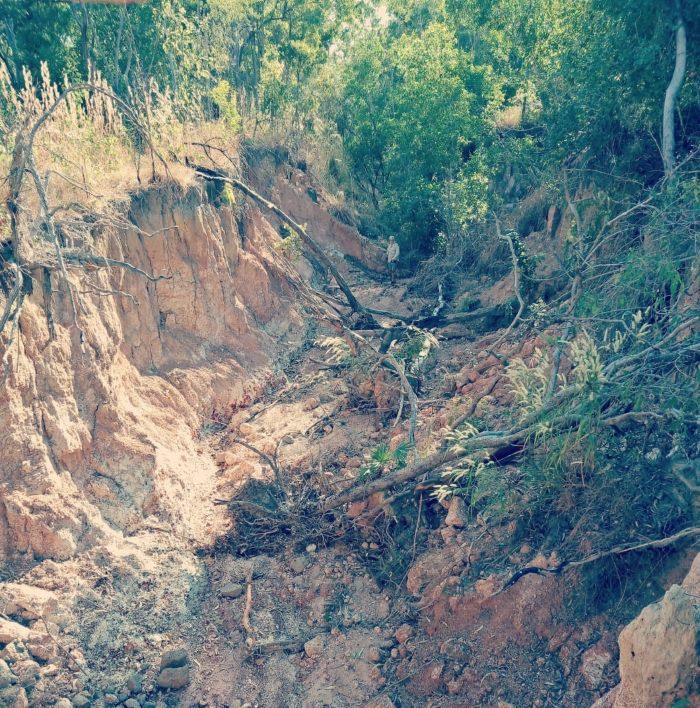
Fig 1. The deepest erosion gully in the Lee Point – 2CRU offset area.
Background
Water polluted with sediment becomes cloudy and;
- prevents animals from seeing food
- reduces sunlight preventing natural vegetation from growing in water
- smothers habitat, disrupting the natural food chain, causing massive declines in fish populations (REF 1).
Soil erosion started at Lee Point – 2CRU many years ago when the land was first cleared for defence purposes. Since then runoff has become more concentrated and erosion is now a significant problem. The erosion problem relates to loss of vegetation (habitat) and thousands of cubic meters of sediment being deposited into the Casaurina Coastal Reserve (CCR) mangroves.
The worst affected area is in the southwest of 2CRU in the area designated as the environmental offset for the Black-footed Tree-rat. This area is due to be transferred from DHA to NT Government and added to CCR.
The erosion problems in the offset area were recognised in the 2015 Notice of Intent (NOI) – prepared for DHA (REF 2) and one erosion gully was identified at this time, refer red dot, excerpt taken from 2015 NOI – Fig 4.6, see figure below.
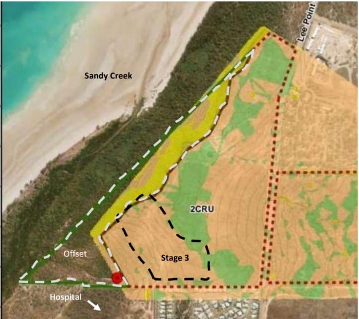
Fig 2. Excerpt taken from 2015 NOI with other information overlaid such as Stage 3 and offset (white dashed line).
The erosion starts in Stage 3 with erosion gullies occuring in the offset area.
According to the 2018 July Environmental Impact Study (EIS) prepared for DHA (REF 3) the erosion problems would be addressed through Erosion Sedimentation Control Plans (ESCP), “…The ESCP will also detail how the erosion gullies in the south west of 2CRU will be rehabilitated” – refer 2018 July EIS – Section 7.3.2.4.
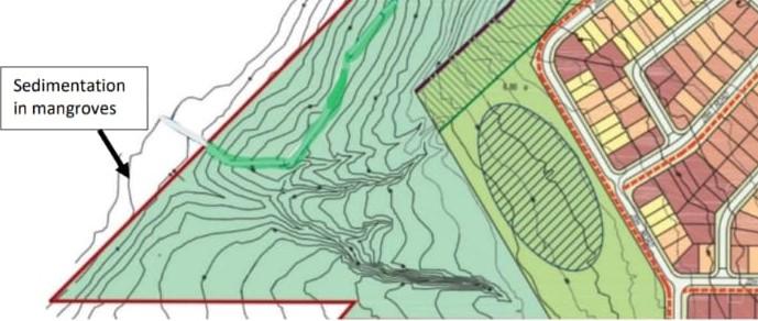
Fig.3 Four gullies shown on this contour map – excerpt from 2018 DHA Masterplan plus sedimention note.
The 2018 NT EPA Assessment Report 88 (REF 4) acknowledged DHA’s commitment to rehabilitating areas through an ESCP and supported this work being carried out.
Recent erosion in the offset area
The stormwater runoff from Stage 3 area is the main cause of downstream erosion problems due to its grade and catchment area. The bare earth in Stage 3 has accelerated erosion over time – refer to newsletter Apr 2022. There are many erosion gullies, the four largest are shown in the photos below.
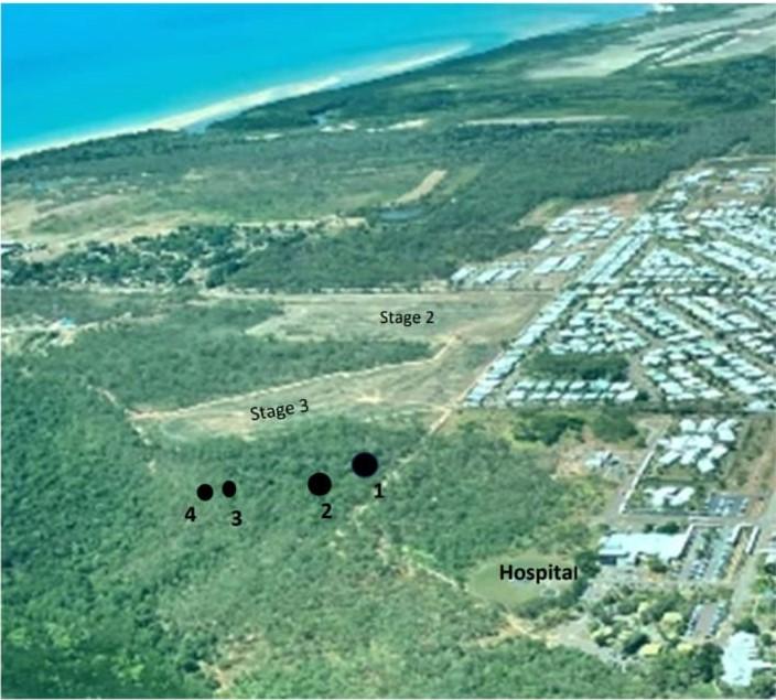
Fig 4. Stage 2 & 3 (approx 18ha) were cleared with bulldozers and chains during 30 Apr-2 May 2024. The black dots represent the start of four significant erosion gullies – see photos below.

Fig 5. Gully No 1 up to 5.5m deep – 2CRU offset area May 2024
This gully is the deepest in the 2CRU offset area, note person in background and collapsing banks from recent erosion.
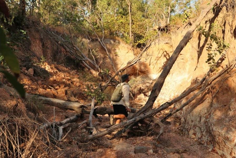
Fig 6. Gully No 1 near the start of gully – May 2024
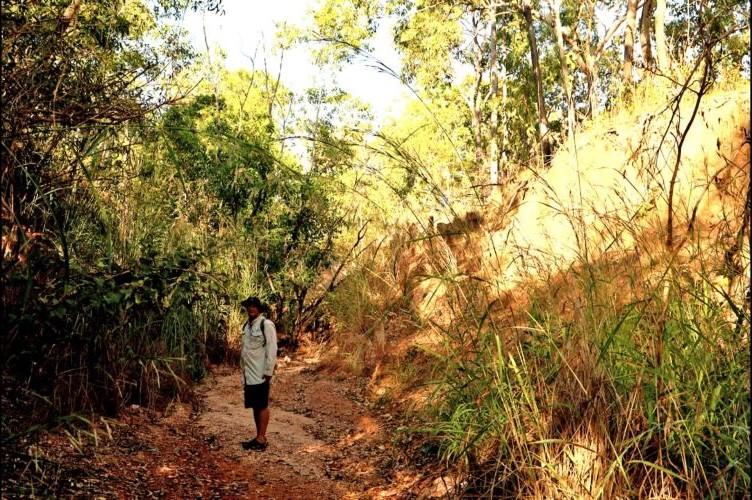
Fig 7. Gully No 2 up to 4m deep – 2CRU offset area May 2024
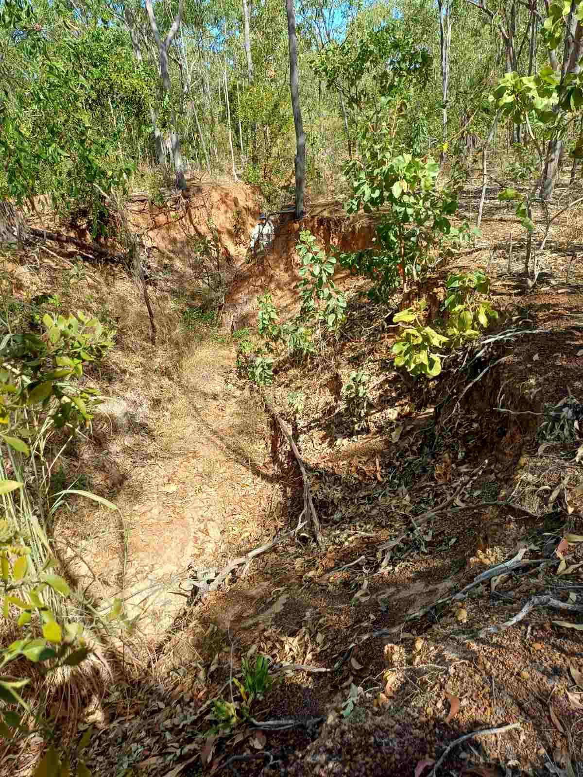
Fig 8. Gully No 3 up to 3m deep – 2CRU offset area May 2024
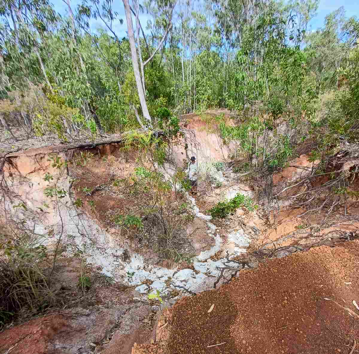
Fig 9. Gully No 4 up to 3m deep – 2CRU offset area May 2024
Fig 10a. Sediment downstream of 2CRU offset erosion gullies, edge of mangroves – May 2024
Fig 10b. Sediment downstream of 2CRU offset erosion gullies, edge of mangroves – May 2024
Fig 10c. 2CRU offset sediment in mangroves with approx 0.1ha die-off of Ceriops mangrove, probably due to sedimentation – May 2024
Recent work upstream of the four 2CRU offset erosion gullies
Fig 11. Stage 3 after it was levelled – photo 8 May 2024 looking towards Lyons.
The vegetation of Stage 3 was levelled by bulldozers and chains in early May 2024. Removing the vegetation from Stage 3 will greatly increase the potential for downstream erosion and sedimentation.
The recent Stage 3 work by DHA is alleged to have happened without an ESCP. A complaint has been lodged with the NT Government.
Discussion
It is not possible to discuss addressing erosion problems on the Lee Point peninsula without looking at future land use.
The DHA Lee Point housing project is not supported by community. FLP believe a comprehensive Area Plan (to determine land use) needs to be completed for Lee Point peninsula by an independent body before any significant development should be allowed.
In the interim, an ESCP should be developed and implemented to deal with the worst erosion problems. It is important that further topsoil is not lost. Soil and vegetation should not be removed from the DHA project site.
There may be opportunities to respread some the cleared vegetation into specific areas to help reduce erosion.
Summary
It is likely that erosion in the 2CRU area will worsen unless some action is taken.
Until a new Lee Point Area Plan can be developed by an independent body;
- An interim ESCP should be developed and implemented to deal with the worst erosion problems, particularly the 2CRU offset area.
- Soil and vegetation should not be removed from the DHA Lee Point project site.